


Discover the Sacred Valley, Maras & Moray: A Journey to the Heart of the Andes
Step into the mystical Sacred Valley of the Incas, where breathtaking landscapes, ancient history, and living culture come together in one unforgettable experience.
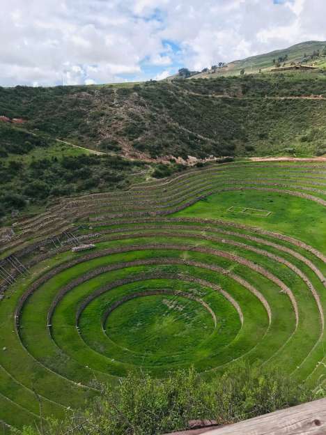
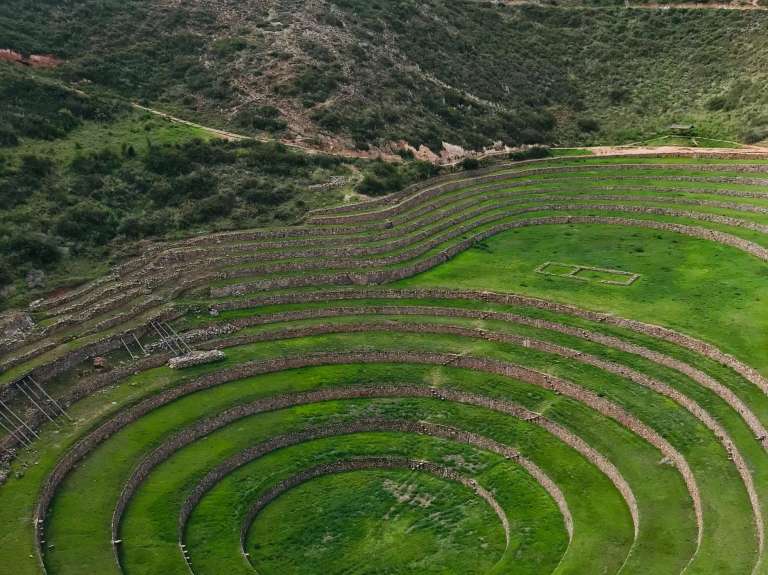
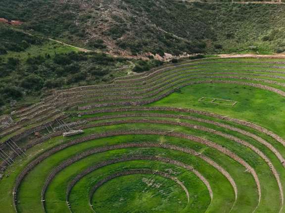
Explore Moray, a fascinating Inca agricultural laboratory with circular terraces unlike anything you've seen before, and marvel at the stunning salt mines of Maras, with over 6,000 salt pools shining like white jewels on the mountainside.
This tour is perfect for travelers looking to connect with the ancestral spirit of Peru while taking in some of the most scenic views in the Andes.

This day we will start with the pick up from your hotel at approximately 7:00 am. to go to the town of Chinchero, where we will find Inca wall constructions and its colonial church that awaits a lot of history, we will also have a small participation in the textile center. Continuing our visit, we will go to the famous circular terraces of cultivation of Moray, this archaeological site was very important in Inca times, especially in agriculture.
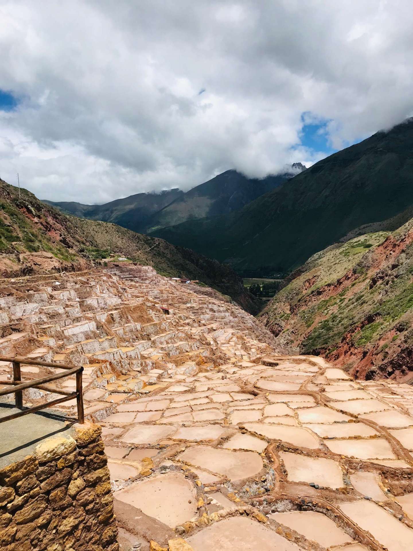
After that we will descend to the salt mines of Maras, a picturesque place for its landscapes; here we will visit more than 3000 salt wells, this salt was used by the Incas for their consumption.
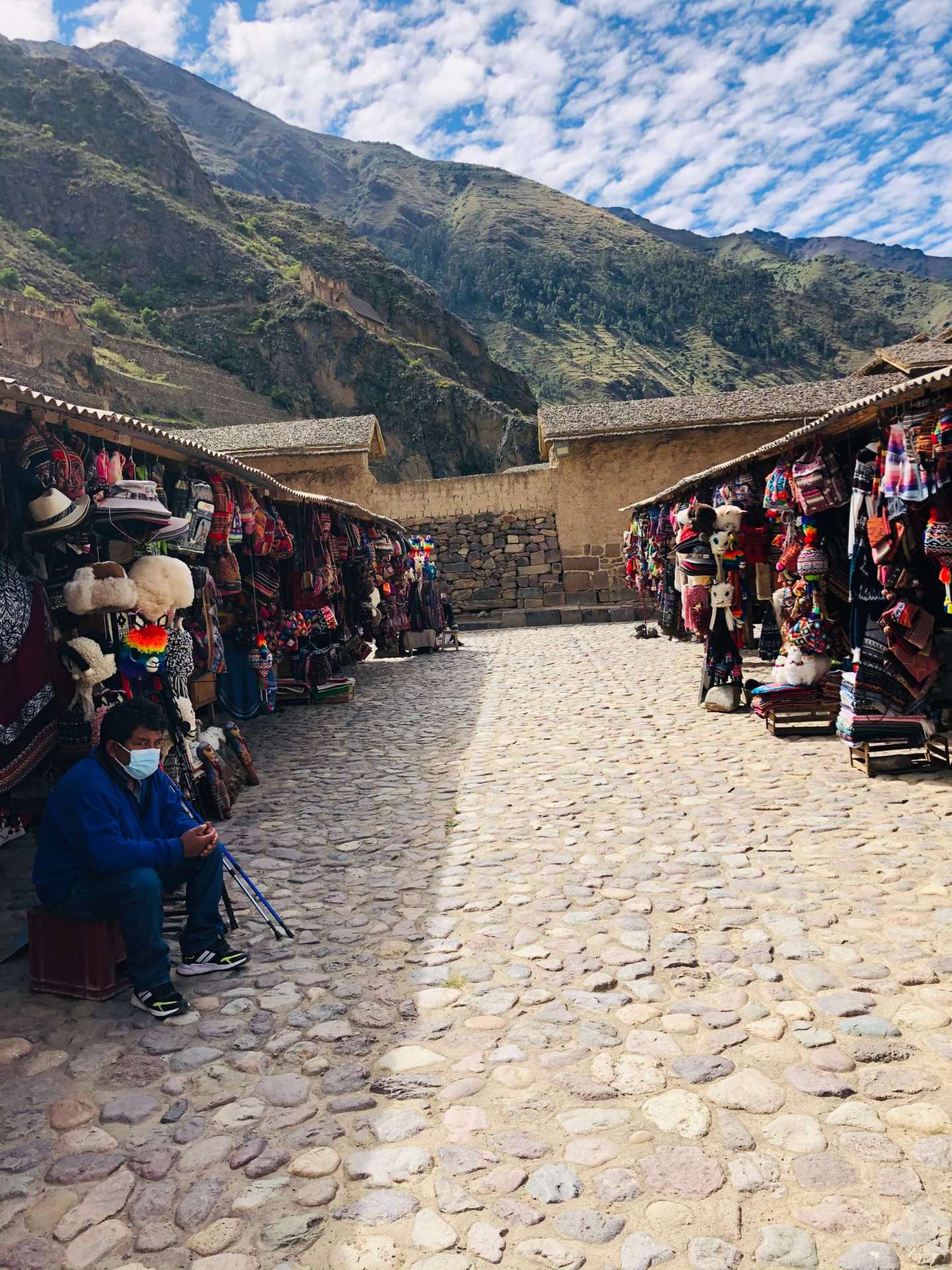
We will arrive to the city of Urubamba where we will enjoy our buffet lunch and continue our trip to Ollantaytambo, known as "The Last Living Inca City".
Once we finish our visit to Ollantaytambo we will go to the picturesque town of Pisac located on the slopes of the Intihuatana hill ("Place where the Sun is tied"), we will enter the indigenous market of Pisac, which is the best place to shop for handicrafts and then finish visiting the Archaeological Park of Pisac, Inca archaeological sites, buildings in polished stone finely assembled.
We will be back in Cusco at 7:00 pm. approximately.
NOTE
It is recommended to bring water or hydration, sunscreen, jacket for the cold, hat and sunglasses. If you carry or buy snacks during the tours, preferably light snacks (dried fruits, cookies and water).
INCLUDED:
NOT INCLUDES:
The archaeological center of Pisac is 33 km away to the east of the city of Cusco, at a height of 3,300 meters above sea level.
Pisaq is a Quechua word, a proper name that does not have a translation into another language, because it does not specifically qualify any object or fact.
This archaeological site is important because it is the entrance to the sacred valley. In addition, it is a strategic place, located at the top of the mountain, and built with several roads that connect with other sections. The most amazing thing about this historical monument are the terraces on different levels that were built to take advantage of the land for cultivation. From the other side of the river, arriving from Cusco, you can see the spectacular terraces on the slopes.
When we reach its top, on foot or by road, we find one of the most fascinating scenarios. The depth of the valley and the projection of the surrounding mountains, transport us to moments of glory and power of the Inca people, who created this orderly city in the mountains: with neighborhoods and terraces perfectly adapted to this exuberant geography.
The large number of terraces show us the care they had for the land and what it produces. The technology of the terraces was not only used for planting, but there was a whole elaborate plan to combine the different arts and techniques so that they are truly functional in diversity.
Pisac is made up of a multiplicity of units related by proximity and functionality, they are groupings in enclosures (neighborhoods), more, areas of huge terraces, aqueducts, paths associated with walls and façades, canalized water channels, cemetery, bridges, etc.
In this Inca city, with a mastery in the distribution of spaces, the sacred area could not be absent; which is case hidden from view from the main roads. The ordering of the ceremonial precincts is, once again, special in relation to astronomical alignments; for which the sages created a solar meter (Intiwatana) in situ, in the rock.
The original meaning of its name has been lost, although today tradition knows this town as the “Land of the Rainbow” because the K’uychi (rainbow) is frequently present in the rainy season.
Chinchero is located in the district of the same name in the province of Urubamba, 30 km. northwest of the city of Cusco; at a height of 3,780 meters above sea level. And on a high-Andean plain.
Between Cusco and Urubamba, on the highway, we find this Inca town; where, as in Olllantaytambo and Pisac, there is a distribution of elements that make it an important center of Inca administration and organization, compared to other communities.
Chinchero was the main population center of the Pampa de Anta at the time of the Incas. It may have been a sizeable city; some historians think that it may have been the capital of a small state, before the fusion and expansion of the Inca culture. Later it is believed that it became the royal state of Topa Inca, son of Pachacuteq.
The city itself is spread over a mighty rise at the head of a valley that leads downward and northeast to the Urubamba River. On a clear day, the views from Chinchero are tremendous: to the west and northwest stretches a view of the undulating plateau, tinged in the distance by the spectacular snow-capped mountains of the Vilcabamba and Urubamba Cordillera.
The main square of the city is famous for its massive Inca wall, with ten of the largest trapezoidal niches known among Inca structures.
It was probably the base wall of a palace, perhaps that of Topa Inca, which once overlooked the plaza, located where the church now stands. The church has a colonial fresco around the portico. Inside it was once beautiful, completely painted, walls and ceiling, with multicolored flowers and patterns. Centuries of neglect nearly destroyed these works of art, but many restorations had been made in recent years.
As you stand in the plaza in front of the church, see to your left, beyond the town, the head of the valley that descends several kilometers to meet the Urubamba at Urquillos, just east of Wayllabamba. The hillsides near the city here are sculpted with ancient terraces.
Maras is located 40 kilometers from Cuzco, in the Sacred Valley of the Incas. It is located at 3,375 meters above sea level.
The Maras salt mine is a place known since time immemorial, and from which the Incas also benefited. It is worth remembering that the Andes have, in their geography, an incalculable wealth of flora, fauna and minerals; and if something was missing for organized societies to live a life of privilege, they simply created it or looked for the scenarios where they could find what they needed.
The salt is dragged by a spring of tempered water, and directed by a network of small channels that lead it to the thousands of ponds, where the water rests and by a thermal process of evaporation it leaves the mineral in its soil as a residue, soon to be picked up. There are thousands of ponds where the water is stored, which carries the call, by some societies of the past, "white gold" or "white sand". And in a very ingenious way they continue to build and restore these ponds that become terraces; being the seasons those that condition its production. Especially in the Andean winter, it is when the harvest becomes more prosperous, allowing a selection of its qualities to be made, and after adding iodine it is ready for consumption. In life, salts are responsible for providing our body with the necessary minerals, and guaranteeing good health.
Mother Earth blessed those who lived in the Sacred Valley, giving them salt flats that flow from approximately 4 veins of salt water. These were used by the first inhabitants of these valleys and by the Incas. Here you can see small constructions made of mud and adobe on the natural rock. It is also observed how the Incas made a store of that salty stone that is found on the salt mines that are still preserved today. Currently, there are around 3,000 salt reservoirs of 5 to 10 square meters each. The process begins with the filling of each tank every 3 to 4 days when there is enough sun and as soon as they dry they are refilled with water until there is a height of 10 centimeters of accumulated salt. The dried salt is then beaten with wood and the first layer that is scraped off qualifies for human consumption. The second layer is for animals and the third is for cultivated land.
The origin of this water remains a mystery that no one has been able to decipher. It is only known that they have been in operation for thousands of years and that they benefit humble families in the Andes.
Moray is a place that is located 7 kilometers from the Maras district, and 53 kilometers from the imperial city of Cusco and is located at an altitude of 3,500 meters above sea level. This place impresses everyone with its deep circular amphitheater.
The ancestral peoples of the region took four huge natural depressions in the landscape and carved them into levels of agricultural terraces that served, hundreds of years ago, as an experimental agricultural station for the development of different varieties of crops. This was made possible by the discovery of a fascinating phenomenon: the climates of many different ecological zones were present in one place.
Moray is a surprising place for its beauty, and of different architecture; the scenic environment makes us recognize the ability of its builders to be inclined to create sacred spaces in such magnificent geographies. It can be seen that they masterfully distributed groups of circular terraces in four spaces; as following the cardinal directions and, at the same time, represented in the magical world to the four elements.
Moray was one of the energetic centers for agricultural experiences and cosmogonic studies, where the disciple of the sacred path was led through the secrets of earth and heaven. From the earth they had to discover its virtues, and make combinations to obtain evolutionary results in the art of sowing; as well as ingeniously using the different degrees of temperature according to the level of the terraces, from their base to the surrounding pampas. Understanding that the Incas were lovers of beauty, they had to combine technology and energy in this place; Because of the ceremonies carried out in this place, the message of works for the preservation of the land that suckles us is received.
In the sacred valley, where the Vilcanota river runs and 70 kilometers northeast of the city of Cusco, the Incas embodied their imperial significance in one of the most fabulous architectural complexes: Ollantaytambo.
Its location between the Inca capital and the jungle, "a particularly useful node in the network of routes", provided it with a strategic military position, as well as for the state administration and the control of the exchange of goods. Precisely that function was assigned by the Inca Wiracocha when he founded a dairy farm there, Ollantay, which was a place of passage, of transitory residence.
It was Pachacutec, the first sovereign of the Hanan dynasty, who modified the destiny of Ollantaytambo and the history of ancient Peru. I command the tambo to be set on fire as a symbol of the end of the Hurin dynasty, to which Wiracocha Inca belonged, and rebuilt it to the dimension of its imperial projection.
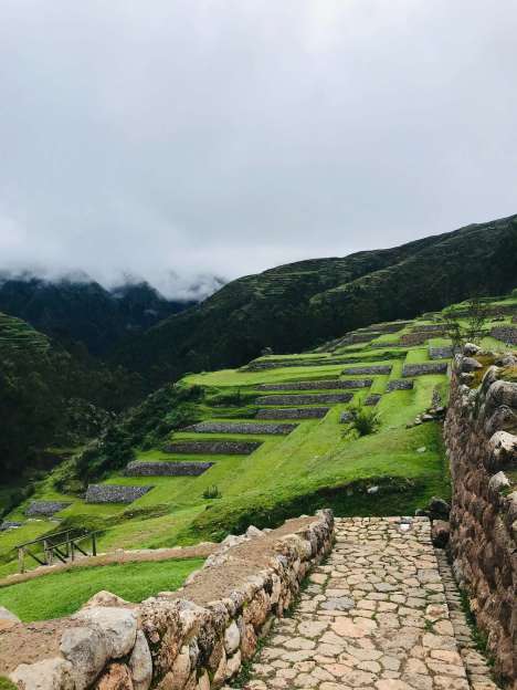
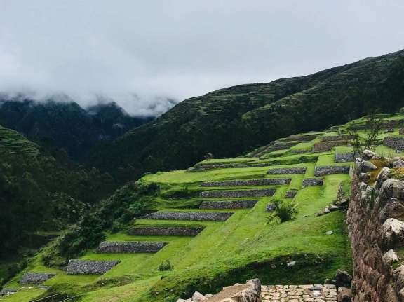
Ollantaytambo is the axis between MacchuPicchu and Cusco. It is the most strategic center of the valley and was considered the second most important city after Cusco. It was also the center of exchange for products such as coca leaves and corn, in a barter system between the towns near the edge of the jungle and with those in the mountains. This place has 600 hectares of archaeological sites that the Incas built along its valleys. Thus, when visiting one of these places you could see terraces, temples, granaries and aqueducts that came down from lagoons or streams with the ultimate purpose of irrigating the terraces in the form of pyramids, along the slopes of the mountains. With the arrival of the Spanish, who did not care much about cultivation, but about gold and silver, they destroyed these terraces or left them in ruins. However, it would only be necessary to clear these terraces to put them back into use.
In this enormous complex, the Incas reiterate their genius in the use of “stone technology on an architectural scale”. It is made up of several ceremonial sites such as the Temple of Water, the Ñusta Bath and the Temple of the Sun with its huge monoliths, among others. In addition, buildings dedicated to astronomical observation, administrative functions, urban, livestock and agricultural areas.
This day we will start with the pick up from your hotel at approximately 7:00 am. to go to the town of Chinchero, where we will find Inca wall constructions and its colonial church that awaits a lot of history, we will also have a small participation in the textile center. Continuing our visit, we will go to the famous circular terraces of cultivation of Moray, this archaeological site was very important in Inca times, especially in agriculture.
After that we will descend to the salt mines of Maras, a picturesque place for its landscapes; here we will visit more than 3000 salt wells, this salt was used by the Incas for their consumption.
We will arrive to the city of Urubamba where we will enjoy our buffet lunch and continue our trip to Ollantaytambo, known as "The Last Living Inca City".
Once we finish our visit to Ollantaytambo we will go to the picturesque town of Pisac located on the slopes of the Intihuatana hill ("Place where the Sun is tied"), we will enter the indigenous market of Pisac, which is the best place to shop for handicrafts and then finish visiting the Archaeological Park of Pisac, Inca archaeological sites, buildings in polished stone finely assembled.
We will be back in Cusco at 7:00 pm. approximately.
NOTE
It is recommended to bring water or hydration, sunscreen, jacket for the cold, hat and sunglasses. If you carry or buy snacks during the tours, preferably light snacks (dried fruits, cookies and water).
INCLUDED:
NOT INCLUDES:
The archaeological center of Pisac is 33 km away to the east of the city of Cusco, at a height of 3,300 meters above sea level.
Pisaq is a Quechua word, a proper name that does not have a translation into another language, because it does not specifically qualify any object or fact.
This archaeological site is important because it is the entrance to the sacred valley. In addition, it is a strategic place, located at the top of the mountain, and built with several roads that connect with other sections. The most amazing thing about this historical monument are the terraces on different levels that were built to take advantage of the land for cultivation. From the other side of the river, arriving from Cusco, you can see the spectacular terraces on the slopes.
When we reach its top, on foot or by road, we find one of the most fascinating scenarios. The depth of the valley and the projection of the surrounding mountains, transport us to moments of glory and power of the Inca people, who created this orderly city in the mountains: with neighborhoods and terraces perfectly adapted to this exuberant geography.
The large number of terraces show us the care they had for the land and what it produces. The technology of the terraces was not only used for planting, but there was a whole elaborate plan to combine the different arts and techniques so that they are truly functional in diversity.
Pisac is made up of a multiplicity of units related by proximity and functionality, they are groupings in enclosures (neighborhoods), more, areas of huge terraces, aqueducts, paths associated with walls and façades, canalized water channels, cemetery, bridges, etc.
In this Inca city, with a mastery in the distribution of spaces, the sacred area could not be absent; which is case hidden from view from the main roads. The ordering of the ceremonial precincts is, once again, special in relation to astronomical alignments; for which the sages created a solar meter (Intiwatana) in situ, in the rock.
The original meaning of its name has been lost, although today tradition knows this town as the “Land of the Rainbow” because the K’uychi (rainbow) is frequently present in the rainy season.
Chinchero is located in the district of the same name in the province of Urubamba, 30 km. northwest of the city of Cusco; at a height of 3,780 meters above sea level. And on a high-Andean plain.
Between Cusco and Urubamba, on the highway, we find this Inca town; where, as in Olllantaytambo and Pisac, there is a distribution of elements that make it an important center of Inca administration and organization, compared to other communities.
Chinchero was the main population center of the Pampa de Anta at the time of the Incas. It may have been a sizeable city; some historians think that it may have been the capital of a small state, before the fusion and expansion of the Inca culture. Later it is believed that it became the royal state of Topa Inca, son of Pachacuteq.
The city itself is spread over a mighty rise at the head of a valley that leads downward and northeast to the Urubamba River. On a clear day, the views from Chinchero are tremendous: to the west and northwest stretches a view of the undulating plateau, tinged in the distance by the spectacular snow-capped mountains of the Vilcabamba and Urubamba Cordillera.
The main square of the city is famous for its massive Inca wall, with ten of the largest trapezoidal niches known among Inca structures.
It was probably the base wall of a palace, perhaps that of Topa Inca, which once overlooked the plaza, located where the church now stands. The church has a colonial fresco around the portico. Inside it was once beautiful, completely painted, walls and ceiling, with multicolored flowers and patterns. Centuries of neglect nearly destroyed these works of art, but many restorations had been made in recent years.
As you stand in the plaza in front of the church, see to your left, beyond the town, the head of the valley that descends several kilometers to meet the Urubamba at Urquillos, just east of Wayllabamba. The hillsides near the city here are sculpted with ancient terraces.
Maras is located 40 kilometers from Cuzco, in the Sacred Valley of the Incas. It is located at 3,375 meters above sea level.
The Maras salt mine is a place known since time immemorial, and from which the Incas also benefited. It is worth remembering that the Andes have, in their geography, an incalculable wealth of flora, fauna and minerals; and if something was missing for organized societies to live a life of privilege, they simply created it or looked for the scenarios where they could find what they needed.
The salt is dragged by a spring of tempered water, and directed by a network of small channels that lead it to the thousands of ponds, where the water rests and by a thermal process of evaporation it leaves the mineral in its soil as a residue, soon to be picked up. There are thousands of ponds where the water is stored, which carries the call, by some societies of the past, "white gold" or "white sand". And in a very ingenious way they continue to build and restore these ponds that become terraces; being the seasons those that condition its production. Especially in the Andean winter, it is when the harvest becomes more prosperous, allowing a selection of its qualities to be made, and after adding iodine it is ready for consumption. In life, salts are responsible for providing our body with the necessary minerals, and guaranteeing good health.
Mother Earth blessed those who lived in the Sacred Valley, giving them salt flats that flow from approximately 4 veins of salt water. These were used by the first inhabitants of these valleys and by the Incas. Here you can see small constructions made of mud and adobe on the natural rock. It is also observed how the Incas made a store of that salty stone that is found on the salt mines that are still preserved today. Currently, there are around 3,000 salt reservoirs of 5 to 10 square meters each. The process begins with the filling of each tank every 3 to 4 days when there is enough sun and as soon as they dry they are refilled with water until there is a height of 10 centimeters of accumulated salt. The dried salt is then beaten with wood and the first layer that is scraped off qualifies for human consumption. The second layer is for animals and the third is for cultivated land.
The origin of this water remains a mystery that no one has been able to decipher. It is only known that they have been in operation for thousands of years and that they benefit humble families in the Andes.
Moray is a place that is located 7 kilometers from the Maras district, and 53 kilometers from the imperial city of Cusco and is located at an altitude of 3,500 meters above sea level. This place impresses everyone with its deep circular amphitheater.
The ancestral peoples of the region took four huge natural depressions in the landscape and carved them into levels of agricultural terraces that served, hundreds of years ago, as an experimental agricultural station for the development of different varieties of crops. This was made possible by the discovery of a fascinating phenomenon: the climates of many different ecological zones were present in one place.
Moray is a surprising place for its beauty, and of different architecture; the scenic environment makes us recognize the ability of its builders to be inclined to create sacred spaces in such magnificent geographies. It can be seen that they masterfully distributed groups of circular terraces in four spaces; as following the cardinal directions and, at the same time, represented in the magical world to the four elements.
Moray was one of the energetic centers for agricultural experiences and cosmogonic studies, where the disciple of the sacred path was led through the secrets of earth and heaven. From the earth they had to discover its virtues, and make combinations to obtain evolutionary results in the art of sowing; as well as ingeniously using the different degrees of temperature according to the level of the terraces, from their base to the surrounding pampas. Understanding that the Incas were lovers of beauty, they had to combine technology and energy in this place; Because of the ceremonies carried out in this place, the message of works for the preservation of the land that suckles us is received.
In the sacred valley, where the Vilcanota river runs and 70 kilometers northeast of the city of Cusco, the Incas embodied their imperial significance in one of the most fabulous architectural complexes: Ollantaytambo.
Its location between the Inca capital and the jungle, "a particularly useful node in the network of routes", provided it with a strategic military position, as well as for the state administration and the control of the exchange of goods. Precisely that function was assigned by the Inca Wiracocha when he founded a dairy farm there, Ollantay, which was a place of passage, of transitory residence.
It was Pachacutec, the first sovereign of the Hanan dynasty, who modified the destiny of Ollantaytambo and the history of ancient Peru. I command the tambo to be set on fire as a symbol of the end of the Hurin dynasty, to which Wiracocha Inca belonged, and rebuilt it to the dimension of its imperial projection.
Ollantaytambo is the axis between MacchuPicchu and Cusco. It is the most strategic center of the valley and was considered the second most important city after Cusco. It was also the center of exchange for products such as coca leaves and corn, in a barter system between the towns near the edge of the jungle and with those in the mountains. This place has 600 hectares of archaeological sites that the Incas built along its valleys. Thus, when visiting one of these places you could see terraces, temples, granaries and aqueducts that came down from lagoons or streams with the ultimate purpose of irrigating the terraces in the form of pyramids, along the slopes of the mountains. With the arrival of the Spanish, who did not care much about cultivation, but about gold and silver, they destroyed these terraces or left them in ruins. However, it would only be necessary to clear these terraces to put them back into use.
In this enormous complex, the Incas reiterate their genius in the use of “stone technology on an architectural scale”. It is made up of several ceremonial sites such as the Temple of Water, the Ñusta Bath and the Temple of the Sun with its huge monoliths, among others. In addition, buildings dedicated to astronomical observation, administrative functions, urban, livestock and agricultural areas.